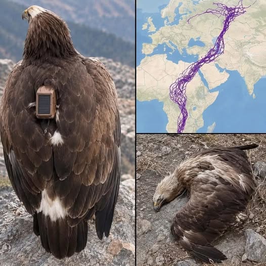
The Viral Legend vs. Reality: The Truth Behind the Steppe Eagle GPS Tracking Map
Few wildlife images have captured the global imagination quite like the map showing an intricate web of purple lines stretching across Europe, the Middle East, and Africa, meticulously tracing thousands of miles while sharply avoiding large bodies of water. For years, social media platforms have shared this graphic alongside a captivating story: the remarkable two-decade journey of a single eagle fitted with a GPS tracker in Russia, which allegedly navigated an extraordinary, land-locked route to avoid flying over the open sea before finally perishing in Saudi Arabia.
While the story paints a breathtaking picture of avian intelligence and resilience, it is a classic example of how a fascinating scientific project can be completely distorted through internet translation errors and viral storytelling.
The Origin of the Viral Myth
The legend typically unfolds with a dramatic narrative: a researcher straps a solar-powered tracking unit to a young eagle. The bird spends the next twenty years traversing continents, faithfully sending signals back home. According to the viral posts, the eagle’s most astonishing behavior was its apparent aversion to water—taking massive, exhausting detours around the Caspian Sea and other major bodies of water just to keep solid ground beneath its wings.
The tale usually concludes with the bird’s discovery in the Middle East—often cited as the “Valley of the Child” in Saudi Arabia—where a local resident finds the carcass, recovers the tracker, and contacts the scientists who originally launched the project two decades prior.
While elements of this narrative contain fragments of truth, the core premise is entirely fictional.
Separating Fact from Fiction: What the Map Actually Shows
Ornithologists and fact-checkers have thoroughly debunked the “20-year single eagle” legend. The reality, though different, is still a triumph of modern ecological research:
- Not 20 Years, But 1 Year: The telemetry data visualized on the map does not span two decades. GPS tracking technology of that scale and battery efficiency was simply not deployed in the configuration suggested for a 20-year continuous archive of this type.
- Not One Eagle, But Twenty: The complex web of purple lines is not the lifetime journey of a single bird. Instead, it is the combined migration data of 20 different steppe eagles tracked over a single year (specifically, a project conducted around 2018).
- The Saudi Arabian Connection: The kernel of truth in the viral post stems from an actual event where a local man in Saudi Arabia discovered a dead steppe eagle equipped with a tracker. When researchers—such as Dr. Todd Katzner and Dr. Elena Bragin, who studied these migratory raptors—were contacted about the find, they shared reference maps of their broader tracking studies to explain the migration patterns of the species. Through a chain of mistranslations across Arabic and English social media channels, the collective map of 20 eagles morphed into the myth of one eagle’s 20-year odyssey.
Why Do Steppe Eagles Avoid the Open Sea?
Though the “20-year lone traveler” story is a myth, the viral observation driving it is fundamentally correct: steppe eagles do go to great lengths to avoid crossing large bodies of water like the Caspian Sea. However, this behavior is driven by physics and biology rather than conscious geographical plotting.
- Reliance on Thermal Currents: Steppe eagles are large, heavy raptors that rely heavily on soaring flight rather than continuous, active flapping. They utilize thermal updrafts—rising columns of warm air generated when the sun heats the earth’s surface—to gain altitude and glide effortlessly for kilometers.
- The Physics of Water: Water features heat up and cool down much slower than land, meaning they do not produce the thermal air currents that land-dwelling raptors require. Flying over a massive body of water like the open sea would force an eagle into exhausting, continuous powered flight without any updrafts to sustain it.
- Energy Conservation and Survival: Crossing hundreds of miles of open water without thermals would risk exhaustion, drowning, or starvation. By hugging coastlines and land corridors, these birds ensure a steady supply of updrafts, food sources, and safe perches.
Conclusion
The viral eagle map remains a powerful reminder of how nature inspires awe. While it does not depict a single veteran bird cheating fate for twenty years, it visualizes the synchronized, instinctual migratory blueprints of an entire species. Understanding the real science behind these tracking projects only deepens our appreciation for the complex strategies migratory birds use to navigate our planet.